
100 Miles of Trails
Did you know that prior to the recent construction of trails by the Salt Lake City Parks and Public Lands Department the Salt Lake City Foothills already had a network of 100 Miles of trails?
Starting in early 2020, Salt Lake City has cut 15 miles of trails in lower City Creek Canyon and above the Avenues, and plans to build another 50 to 60 miles of trails during the next two phases of their Foothills Trails System Plan. These additional trails will be crowding an already dense Foothills trail network, and many of the proposed trails are adjacent to existing legacy trails that have been used for decades. Are more trails really necessary?
Let's maintain and manage the trails we have.
Save Our Foothills is requesting that Salt Lake City conduct a full inventory of existing trails as part of a comprehensive land use and recreation management plan. This is an essential step in developing a sustainable trail system.
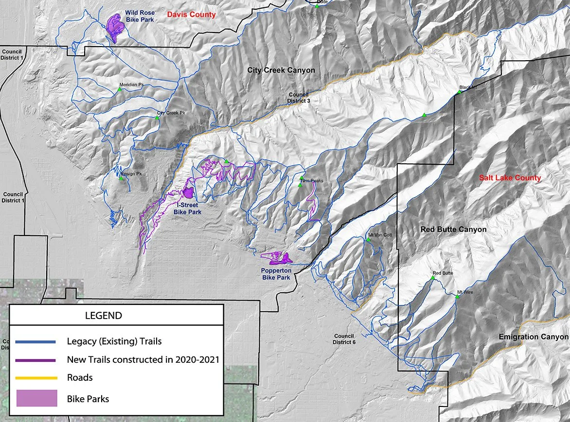
Shaded Relief map of the Salt Lake City Foothills showing Pre-2020 Legacy Trails and all New Trails constructed in 2020-2021

Shaded Relief Map of the Salt Lake City Foothills Showing Pre-2020 Legacy Trails, Trails Constructed during 2020 and 2021, and Planned Trails (red lines)
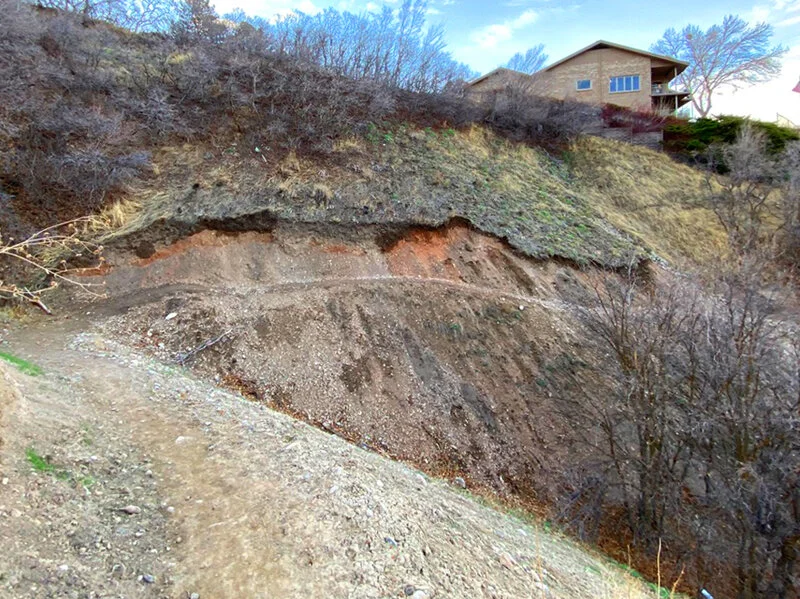
Erosion, January 2021

February 2021

May 2021

One of the goals of Save Our Foothills is to ensure that appropriate scientific research is done BEFORE trails are constructed in the Foothills.
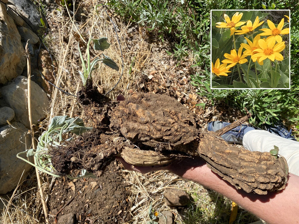
Native plants dug up by the tens of thousands, Spring 2021. This is an Arrowleaf Balsamroot. Annual flower (very old root)

SLC did not tell the environmental survey team their plan to trench the ridgeline. Their plan stated it would be signed and fenced to route users to a new trail.

The Trail plan says trail building is “unsuitable” on slopes that exceed a slope of 20%, yet many slopes in the foothills exceed 55%, such as this one, which results in huge sidewalls, and a high likelihood of landslides and trail washouts.

Gully cutting across the trail below Bonneville Blvd was deepened and widened during the rainstorm, August 1, 2021.

After a rainstorm, Oct 25, 2021, this gully undercut Bonneville Blvd causing extensive damage to the road bed, requiring major repairs by the SLC Road Department.

What Will Our Legacy Be?
Map above of the foothills shows the largest roadless area in Salt Lake County, protected from roadbuilding by the U.S. Forest Service — these last vestiges of undisturbed habitat are important for ecological resilience.
The Wasatch Mountains are an icon of Salt Lake City, recognized for world class skiing, biking, hiking, birding, and delicious drinking water. We also enjoy the quickest, most convenient access to natural areas and wildernesses of any city in the country. Due to this proximity these precious lands are now threatened; pressure from an increase in population is resulting in heavy-handed reactive development, the spreading of non-native invasive plants, interference with essential riparian areas, and destruction of vital wildlife habitats. SLC Foothills needs your help! We must preserve and restore the Foothills today — for wildlife, plant life, and human enjoyment tomorrow.

Hike the Foothills
Hike the foothills trails above the Avenues and in City Creek to see Phase I damage. Study the Phase II Plan — plan includes many new trails on Mt. Wire, trails up Mt. Van Cott, Black Mountain, Twin Peaks and Meridian Peak. Become informed! Get involved!
Link to SLC Trails Master Plan

SLC Trails Survey
You can take this survey several times and comment on more than 5 trails. What you like, what you don’t like, what can we change?